The Hard Rock Catalog is online! It is the comprehensive documentation of the new layer “hard rock occurrences” on map.geo.admin.ch.
It is the impressive result of 5 years of work: in the field, in the laboratory, in the team, in the archives and, mainly, at the desktop :-).
Our blog post on the geology along the UCI Championships road cycling route is online!
Check out our blog post on the geology along the UCI 2024 World Championships route in the Winterthur-Zurich area.
And there is more to discover on geo.sports.org!
Hard rock occurrcences map.geo.admin layer online!
After almost 5 years of work, the map.geo.admin.ch layer showing Switzerlands hard rock occurrences was published this week.
The project was led by our colleague Lukas Nibourel and Thomas Galfetti (swisstopo). Many geoscientists from swisstopo and our group (team members, BSc students, MSc students, Hilfsassistants) were contributing are warmly thanked!
See further information also on mat-min.ch/de/hartstein.
Welcome Kevin Frings!
We welcome our new team member Dr. Kevin Frings joining our team on April 1st 2024.
Kevin completed his PhD in thermochronometry and structural geology in summer 2023 at RWTH Aachen University in cooperation with PLUS University Salzburg . He will work in our new project on producing a new heat flow map of Switzerland, in collaboration with the Swiss Geological Survey at swisstopo.
Annual Report 2023 is published
Our Annual Report 2023 is published. Have a look at our last year’s project results, publications and more.
Welcome Veronique Sieber!
We welcome our new team member Veronique Sieber joining our team on October 1st 2023.
Veronique completed her MSc studies in our Department of Earth Sciences at ETH Zürich in fall 2023. She will work in our project on evaluating clay occurrences in Switzerland for CO2-optimised cement production, in collaboration with the Swiss Geological Survey at swisstopo.
We are hiring!
Join our team for the position “Wissenschaftliche:r Mitarbeiter:in im Bereich Georessourcen (m/w/d)”, starting on 01.10.2023 or by agreement. You’ll find all the info in the official ETH job advertisment here.
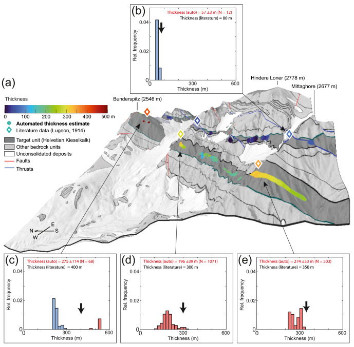
Paper on a new approach to extract stratigraphic thicknesses from geological maps
We are happy to announce the paper by our team member Lukas Nibourel together with colleagues from the Swiss Geological Survey at swisstopo and from our group.
The paper presents an innovative approach to automatically extract orientation (dip direction/dip) and stratigraphic thickness from a 1:25′000 geological map vector data set of the Swiss Alps.
The approach is developed as a part of a mineral resources mapping project funded by swisstopo. It allows a rapid spatial overview on the orientation and thickness of a given geological unit over large areas. It is designed to support authorities and the industry in performing a rapid screening of a given region and to early identify promising areas for potential mineral extraction projects. Large-scale spatial overviews on the orientation and thickness of geological units are of large interest in many other disciplines such as tectonic and stratigraphic reconstruction, hydrogeological or geotechnical analyses.
Nibourel, L., Morgenthaler, J., Grazioli, S., Schumacher, I., Schläfli, S., Galfetti, T. & Heuberger, S. (2023). Automated extraction of orientation and stratigraphic thickness from geological maps. Journal of Structural Geology, 104865.
Welcome Niklaus Kressig!
We welcome our new team member Niklaus Kressig joining our team on April 1st 2023.
Niklaus completed his MSc studies in our Department of Earth Sciences at ETH Zürich in fall 2022. Since then he worked as a trainee at the Office for Waste, Water, Energy and Air (AWEL) of Canton Zurich.
Niklaus will work in our HTC coal project, in collaboration with a Swiss industry partner, and in our forthcoming project on evaluating clay occurrences in Switzerland for CO2-optimised cement production, in collaboration with the Swiss Geological Survey at swisstopo.